Maptech iPlot 1.10.51
Paid Version
Publisher Description
Maptech iPlot - Real Time Chart Plotting App
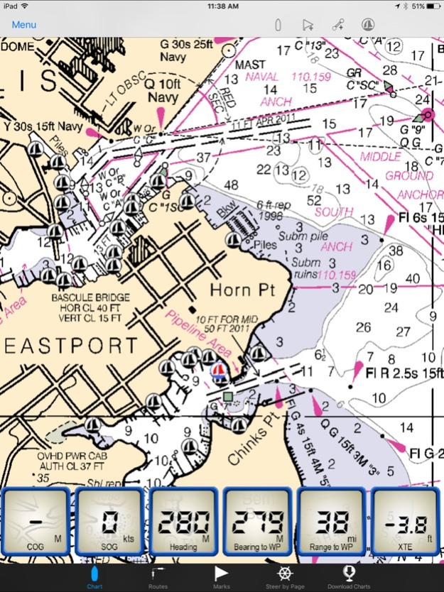
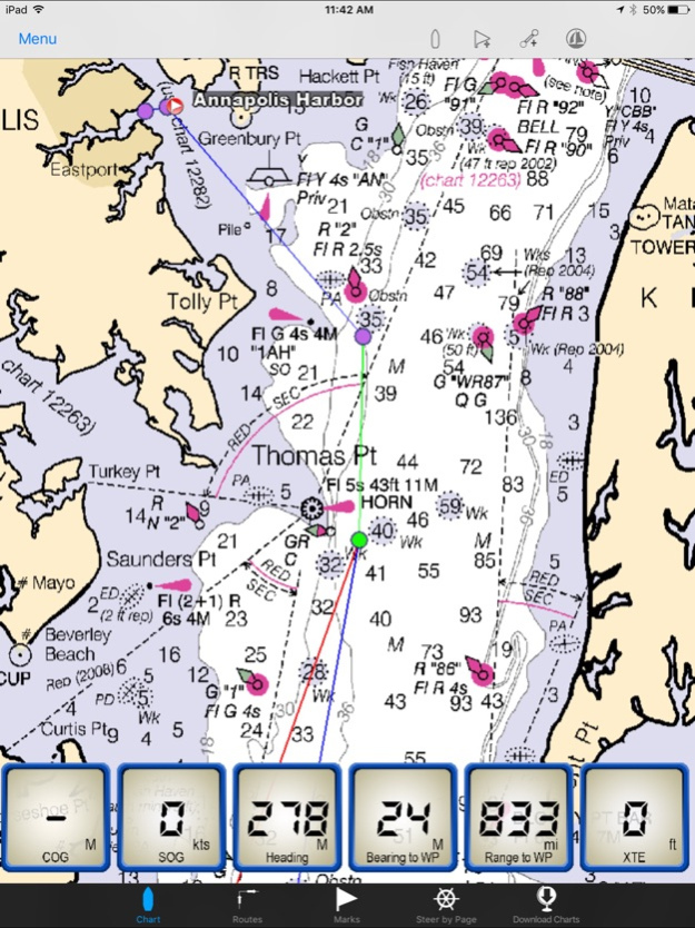
The Maptech iPlot app is simple to use chart plotter app that utilizes many of the same routing functions that Maptech uses in their digital software. The iPlot uses the same NOAA nautical charts you are familiar with from Maptech chart plotting programs such as Offshore Navigator, Chart Navigator Pro, Sea Ray Navigator and i3 Navigator. Plan routes, place marks, and easily zoom and scale charts with your fingers. The iPlot features a smooth and fast chart quilting engine that makes going from one chart to the other seamless. Once the app and charts are downloaded no data connection is required for operating the iPlot app.
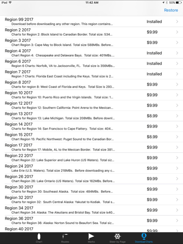
The Maptech iPlot App purchase includes all US small scale planning charts which can be downloaded from the Chart Download page within the app. To accurately navigate with the Maptech iPlot App you will need to purchase a region of charts for your area of interest. These chart regions can be download from within the app itself from the Chart Download page at an additional cost of $9.99 each. All charts are updated every January and neither the app or the charts require a subscription fee nor will they ever expire.
Features include:
Uses NOAA Raster Charts (RNCs)
Full US Chart Coverage available
Lightning fast chart quilting engine
Unlimited custom routes and marks creation
Index of all routes and marks
Place Mark at vessel function for MOB or an anchor alarm
Instant waypoint with a touch of the finger
Full route list of all waypoints showing instant DTW, BTW and ETA to each
Full mark list showing instant DTW, BTW and ETA to each
Reverse route function
Easy method for inputting your already created routes
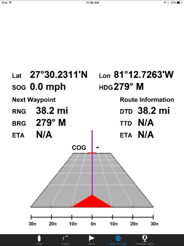
Unique route steering by highway display page
Adjustable waypoint arrival time
Easy to read data windows for COG, SOG, HDG, BTW, RTW, XTE
Easy locate vessel button
Orientations include heads up, north up, look ahead
Choose bearings True or Magnetic
Import/Export from Offshore Navigator
Maptech facilities
WIFI AIS targets
Chart Regions:
Region 02 - Block Island, RI to the Canadian Border
Region 03 - New York to Nantucket and Cape May, NJ
Region 04 - Chesapeake and Delaware Bays
Region 06 - Norfolk, VA to Florida including the ICW
Region 07 - Florida East Coast and the Keys
Region 08 - Florida West Coast and the Keys
Region 10 - Puerto Rico and the U.S. Virgin Islands
Region 12 - Southern California: Point Arena to the Mexican Border
Region 13 - Lake Michigan
Region 14 - San Francisco to Cape Flattery
Region 15 - Pacific Northwest: Puget Sound to the Canadian Border
Region 17 - Mobile, AL to the Mexican Border
Region 22 - Lake Superior and Lake Huron (U.S. Waters)
Region 24 - Lake Erie (U.S. Waters)
Region 26 - Lake Ontario (U.S. Waters)
Region 30 - Southeast Alaska
Region 32 - South Central Alaska: Yakutat to Kodiak
Region 34 - Alaska: The Aleutians and Bristol Bay
Region 36 - Alaska: Norton Sound to Beaufort Sea
Region 40 - Hawaiian Islands and U.S. Territories
If your iPad was purchased with the ability to subscribe to a data plan from your provider, it already has a built in GPS and does not require a Wi-Fi or external GPS to navigate with the iPlot app. You can tell this easily by looking at the top display bar to see if you have the indicator bars for cell strength, if you do then you have a GPS built in. If not, your iPad does not have a built in GPS and you will need to turn on location services and Wi-Fi capability to receive your location to navigate with the iPlot app. However, if you plan on using this outside of urban areas where there is no location services network, you will lose the ability to track your position. It is highly recommended that if you plan on using the Maptech iPlot for real time navigation and your unit is one without a GPS that you use it with an external plug in or bluetooth GPS. We recommend the Bad Elf GPSs. We also recommend Snow Lizard Products iPad cases which have optional Bad Elf GPS receivers built in.
Dec 26, 2023
Version 1.10.51
Corrects issue with iOS version 17
About Maptech iPlot
Maptech iPlot is a paid app for iOS published in the Recreation list of apps, part of Home & Hobby.
The company that develops Maptech iPlot is Nautical Solutions International, Inc.. The latest version released by its developer is 1.10.51. This app was rated by 2 users of our site and has an average rating of 4.0.
To install Maptech iPlot on your iOS device, just click the green Continue To App button above to start the installation process. The app is listed on our website since 2023-12-26 and was downloaded 105 times. We have already checked if the download link is safe, however for your own protection we recommend that you scan the downloaded app with your antivirus. Your antivirus may detect the Maptech iPlot as malware if the download link is broken.
How to install Maptech iPlot on your iOS device:
- Click on the Continue To App button on our website. This will redirect you to the App Store.
- Once the Maptech iPlot is shown in the iTunes listing of your iOS device, you can start its download and installation. Tap on the GET button to the right of the app to start downloading it.
- If you are not logged-in the iOS appstore app, you'll be prompted for your your Apple ID and/or password.
- After Maptech iPlot is downloaded, you'll see an INSTALL button to the right. Tap on it to start the actual installation of the iOS app.
- Once installation is finished you can tap on the OPEN button to start it. Its icon will also be added to your device home screen.
